
Planning your visit and wondering how to get to Siesta Key Beach?You’re in the right place. The top-rated Florida beach has easy access through flying or driving or using GPS navigation. Located near Sarasota on Florida’s Gulf Coast, Siesta Key Beach is famous for its powdery white sand and laid-back atmosphere.
The drive into Siesta Key is as picturesque as the destination itself. The bridge offers a view of palm trees dancing in the breeze as sailboats glide through the bay and pastel-colored houses blend into the mangrove forest. Your vacation starts at this point before you set foot on the beach.
The guide provides complete information about Siesta Key Beach starting with airport identification and ending with map location display. The article will provide you with the most efficient driving directions and essential travel advice and Google Maps links to get to this destination without any problems.
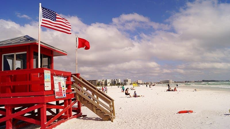
Table of Contents
Where is Siesta Key Beach Located on the Map?
Siesta Key Beach is located off the coast of Sarasota, Florida, on the Gulf of Mexico. It’s a barrier island just south of Tampa and west of downtown Sarasota. If you’re searching for Siesta Key Beach on the map, you’ll find it nestled between Roberts Bay and the sparkling Gulf waters.
This tropical destination is known for its soft quartz sand and vibrant beach town vibes, making it one of the top-rated Florida Gulf Coast beaches. While it feels like an island retreat, Siesta Key is easily accessible via two main bridges—Siesta Drive (State Road 758) and Stickney Point Road (State Road 72).
Want to see exactly where it is? Use this interactive map to zoom in, explore the island, and find key locations:
📍 View Siesta Key Beach on Google Maps
Once you locate Siesta Key Beach, you can explore its surrounding areas, including Siesta Key Village, Crescent Beach, and Turtle Beach. You’ll also find directions, traffic updates, and nearby restaurants or hotels with just a click.
A Scenic Arrival That Sets the Mood
As you head closer to the island, the urban buzz of Sarasota begins to fade. The area transforms when palm trees start to line the streets and local stores begin to appear. The air takes on a salty flavor while everything around you becomes more vibrant and the environment produces a soothing rhythm that transports you to a state of vacation relaxation. The entrance symbol of the bridge leads people to an island where visitors stroll at a relaxed pace while showing wide smiles. The journey starts when the mainland fades from view and you enter the experience that awaits you.
The Siesta Key Beach Travel Guide

Driving Directions to Siesta Key Beach from Major Cities
If you’re traveling by car and wondering about the directions to Siesta Key Beach, it’s easy to access from several major Florida cities. The drive offers scenic views, smooth highways, and plenty of rest stops along the way.
From Tampa (about 1 hour 15 minutes):
Take I-75 S toward Naples.
Exit at 205 (Clark Rd/State Road 72).
Drive west on Clark Road; it becomes Stickney Point Road.
Cross the Stickney Point Bridge and follow signs to Siesta Key Beach.
Orlando to Siesta Key Beach: Your Best Route (2 hrs 15 min)
Take I-4 W toward Tampa.
Merge onto I-75 S via Exit 9.
Exit at 205 (Clark Rd) and follow the same path to Stickney Point Bridge.
Fort Myers Drive to Siesta Key: Scenic and Simple (1 hr 30 min)
Take I-75 N.
Exit at 205 and head west on Clark Road to Siesta Key.
All routes will lead you directly into Siesta Key, where signs will guide you toward Siesta Key Beach access points, including the main parking area.
🗺️ For real-time directions:
📍 Get Driving Directions on Google Maps
Plan your route ahead to avoid peak traffic, especially during holidays or weekends when beachgoers head out early.
You can find more nearby spots and travel inspiration through the Sarasota County official tourism site.
Closest Airport to Siesta Key Beach: SRQ and More
If you’re flying in, the closest airport to Siesta Key Beach is Sarasota-Bradenton International Airport (SRQ). Located just 11 miles away, it’s your quickest gateway to this beach paradise.
Sarasota-Bradenton International Airport (SRQ):
25-minute drive to Siesta Key Beach
Offers direct flights from major U.S. cities
Uber, Lyft, and car rentals available at the terminal
Ideal for travelers who want convenience and speed
Travelers often underestimate the convenience of flying into smaller regional airports. With shorter lines, quicker baggage claim, and more relaxed terminals, your post-flight stress disappears fast. SRQ offers that laid-back arrival experience that complements the island vibe perfectly. You’re not rushing to catch trams or navigating endless gates. Instead, you can be in your rental car and rolling toward the coast in under 20 minutes. Plus, the scenic drive from the airport offers its own preview of the tropical landscapes that await.
Other Nearby Airports Include:
Tampa International Airport (TPA) – 70 miles north (~1.5-hour drive)
Southwest Florida International Airport (RSW) in Fort Myers – 90 miles south (~1.5-hour drive)
St. Pete–Clearwater International Airport (PIE) – ~75 miles away
While SRQ is the most convenient, larger airports like TPA often offer more flight options and cheaper fares. Depending on where you’re coming from, it may be worth checking all three.
📍 View Sarasota Airport to Siesta Key Beach Route
Airport Closest to Siesta Key Beach: Travel Time Comparison
Choosing the airport closest to Siesta Key Beach often comes down to balancing convenience with flight availability. Here’s a quick comparison of top airports and travel times to the beach:
| Airport | Distance to Siesta Key Beach | Drive Time |
| Sarasota-Bradenton (SRQ) | 11 miles | 25 minutes |
| Tampa International (TPA) | 70 miles | 1.5 hours |
| Southwest Florida (RSW) | 90 miles | 1.5 hours |
| St. Pete-Clearwater (PIE) | 75 miles | 1 hour 40 minutes |
| Orlando International (MCO) | 130 miles | 2.5 hours |
If you prioritize being on the sand as quickly as possible, SRQ is the best option. But if you need more flights or better deals, Tampa and Fort Myers are excellent alternatives.
All airports offer rental cars, and rideshare services operate across the region. Plan ahead and book early, especially during peak travel seasons.
Map of Siesta Key Beach and Key Access Points
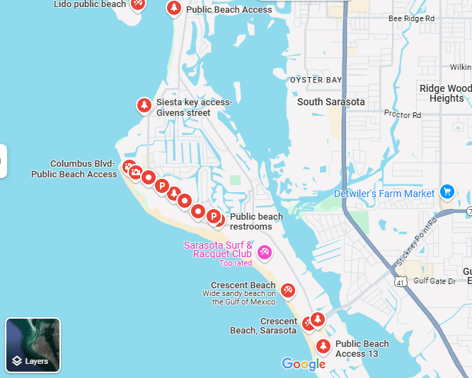
To make the most of your visit, knowing the layout of Siesta Key Beach on the map is essential. The beach has multiple access points, and some are better than others depending on your goals—parking, seclusion, or proximity to food and shops.
Here are some key access points you’ll find on the map:
Access 1–4: Closest to Siesta Key Village
Access 5: Main public beach with parking, lifeguards, and restrooms
Access 7–10: Quieter, less crowded spots for locals and repeat visitors
Access 13: Ideal for Crescent Beach and staying near condos
📍 Check Siesta Key Beach Public Access Map
Using Google Maps, you can also:
Zoom into satellite view for beach paths and parking
Identify real-time traffic and parking situations
Pin your resort or hotel for easy navigation
Pro tip: Save your favorite access points in the app for quick reference when driving or walking.
Tips for First-Time Visitors Driving to Siesta Key Beach
Your first drive to Siesta Key will be a beautiful experience but you should know some local advice to enhance your journey. The knowledge of local tips becomes essential when you travel to Sarasota whether you start from Sarasota or arrive from a big city.
The beach community provides an effortless sense of home comfort to its residents. The local residents will direct you to their preferred taco restaurant while suggesting the perfect location to see the sunset. Take any road you want to purchase fresh citrus fruits and handmade souvenirs from local roadside vendors. Visitors who leave the main tourist zones will discover hidden vacation moments which include listening to beach musicians during sunset and finding hidden coastal areas through hidden walking trails.
Start Early
The earlier you hit the road, the better. Siesta Key Beach gets busy fast, especially on weekends and holidays. Aim to arrive before 9:30 a.m. to snag a parking spot and avoid the lines.
Use Stickney Point Road or Siesta Drive
There are two main bridges connecting the mainland to Siesta Key:
Siesta Drive (State Road 758): Takes you to the north end near Siesta Village.
Stickney Point Road (State Road 72): Brings you to the southern area near Crescent Beach.
Stickney Point is typically more direct, but it can be congested mid-morning. Plan based on where you’re staying.
Avoid Peak Traffic Times
Traffic peaks between 10 a.m.–1 p.m. and again around sunset (6–7:30 p.m.), especially during tourist season. Use real-time traffic via Google Maps to avoid backups.
Bring a GPS Backup
Mobile signals can be spotty on parts of the island. Save offline directions on Google Maps or carry a printed map as a backup.
Bonus tip? Keep your eyes open—Siesta Key’s scenic drive is one of the most beautiful in Florida.
Locals often suggest stopping for a coffee or snack before hitting the bridge. There’s a fantastic café on Clark Road where travelers fuel up for their beach day. Taking a short break here can help avoid bridge traffic and add a relaxed start to your adventure.
Using GPS and Google Maps to Navigate Siesta Key
Navigating Siesta Key is a breeze with Google Maps or your favorite GPS app. Whether you’re searching for parking, resorts, or beach access points, having accurate directions makes all the difference.
How to Use Google Maps Effectively:
Search “Siesta Key Beach access” for all 13 entry points
Tap “Directions” to choose your starting point
Switch to “Satellite View” to get a real-time look at beach paths, parking lots, and road layouts
Use “Save” to pin locations like your hotel or favorite restaurant
📍 Open Google Maps to Explore Siesta Key Beach
GPS will also help you navigate the roundabouts on the island and avoid no-turn zones. After parking you can use Google Maps to find walking directions to nearby restaurants and stores and other entry points.
The application provides bike-friendly route information to users who plan to ride bicycles or rent scooters.
Public Transportation and Shuttles to Siesta Key Beach

Don’t feel like driving? You’ve got options! Public transportation and local shuttles to Siesta Key Beach make getting around easy—even without a car.
Siesta Key Breeze Trolley
Free and fun: Runs every 30 minutes
Covers the island from Turtle Beach to Siesta Key Village
Great for hopping between beaches, shops, and restaurants
Operates daily from 8 a.m. to 10 p.m.
No reservation needed—just hop on at any stop!
More info here: Visit Sarasota – Breeze Trolley Details
SCAT (Sarasota County Area Transit)
Routes connect Sarasota city to Siesta Key
Buses are clean, affordable, and run frequently
Ideal for travelers staying inland or at budget hotels
Shuttle Services & Rideshare
Sunride Transportation, Jonny’s Original Free Rides, and Siesta Key Frog Hop offer free or low-cost local rides
Uber and Lyft are also widely available
These services are especially helpful when parking is full or you just want to explore without worrying about the car.
Parking Information for Siesta Key Beach Visitors
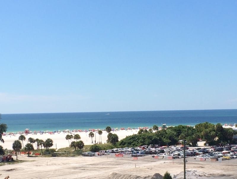
Let’s be real—parking at Siesta Key Beach can be a bit of a mission, especially during peak hours. Knowing your options can save you time and headaches.
Main Public Beach Parking Lot (Access 5):
FREE and fairly large
Open from 6 a.m. to 10 p.m.
Fills quickly—get there early
Access Point Parking (Access 1–13):
Some access points offer street-side or small lot parking
Spaces are limited, so they fill fast
Watch for resident-only signs to avoid getting ticketed
Village Parking Lots:
Several paid lots in Siesta Key Village
Prices range from $5 to $15/day
Great for combining beach time with shopping or dining
Disabled parking:
Designated spots available at all major access points
Many areas are ADA-compliant with ramps and pathways
Pro tip: Use the ParkMobile App where available for cashless meter payments and spot reservations. Also, check the Sarasota County Beaches App for real-time updates on parking lot status.
Best Time to Travel to Siesta Key Beach
Timing your trip right can mean the difference between a peaceful beach day and fighting for a towel spot. Here’s when and how to plan your travel to Siesta Key Beach.
Ideal Times to Plan Your Visit to Siesta Key Beach:
March to May and October to early December offer warm weather and fewer crowds
These months avoid the heavy rains of summer and winter’s high-season prices
Best Days of the Week:
Weekdays are quieter
Steer clear from taking time off during Memorial Day and July 4th and Labor Day.
Ideal Time of Day:
Arrive before 9:30 a.m. for the best parking and beach space
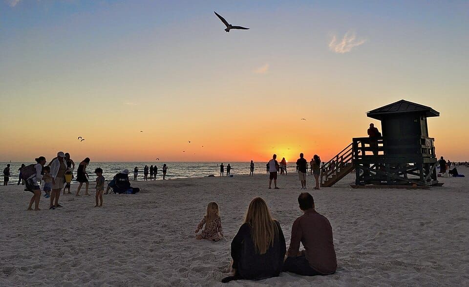
Evening visits (after 5 p.m.) offer cooler temps and stunning sunsets
Planning around these times helps you make the most of your beach adventure. You will also save time by avoiding the need to wait in line and deal with traffic congestion and parking difficulties.
The Gulf sunset produces a magical instant which turns the horizon into a stunning display of orange and pink hues. The beach becomes a serene masterpiece when waves touch the shoreline and the space is filled with happy sounds from people. The experience leaves an enduring impression which accompanies you throughout your entire travel experience.
The local environment creates its own time measurement system which operates during evening hours. As the sun begins to dip below the Gulf, the beach takes on a golden hue and everything seems to slow down. The evening brings people together for walks with their partners and families to swim one more time before they spread out blankets for evening picnics. The soothing combination of ocean waves meeting the beach and beach bar melodies and joyful sounds of people creates a peaceful musical experience. The beach reveals its peaceful nature during these peaceful moments which bring both serenity and enchantment.
Nearby Landmarks and Attractions
While Siesta Key Beach is the star of the show, the surrounding area offers tons of great spots worth exploring. Whether you want to dive into nature, shop local, or indulge in fine dining, there’s something close by for everyone.
Top Attractions Near Siesta Key Beach:
Siesta Key Village: Just a short walk from the beach, this charming area is filled with boutiques, seafood spots, coffee shops, and nightlife.
Point of Rocks: A popular snorkeling and diving site on the southern end of Crescent Beach. It’s less crowded and teeming with marine life.
Turtle Beach: Quieter than Siesta Beach, ideal for kayaking, shell hunting, and picnicking.
Marie Selby Botanical Gardens: Located in nearby Sarasota, these gardens are filled with non-native plants and beautiful views.
St. Armands Circle: A 20-minute drive from Siesta Key, this upscale shopping and dining district is a great place to spend an afternoon.
Mote Marine Laboratory & Aquarium: Fun and educational for families, this spot is home to manatees, sharks, and more.Mote Marine Laboratory & Aquarium: Fun and educational for families, this spot is home to manatees, sharks, and more.
The proximity of these landmarks makes Siesta Key an ideal basecamp. The beach provides multiple activities for visitors who choose to stay from a weekend up to a full vacation.
Conclusion
Wrapping up your visit to Siesta Key Beach, one thing’s for sure — this isn’t just another Florida stop. The location creates a relaxing atmosphere which forces visitors to reduce their speed while breathing deeply as they experience genuine vacation relaxation. The first view of turquoise water creates a distinct impression when you arrive at Siesta Drive through the Stickney Point Bridge.
Once you’re here, everything just flows — from finding a shaded spot on the powdery quartz sand to grabbing a cold drink at Siesta Key Village. The beach really does live up to its reputation as one of the best beaches on Florida’s Gulf Coast. Google Maps will help you plan your route and parking and access points so you can have a stress-free beach day.
Siesta Key Beach provides its visitors with a combination of soft sandy beaches and a quaint small-town atmosphere. Arrive early and stay until nightfall to witness the sunset create its own magic because certain experiences exceed the value of taking pictures. The moment you finish brushing sand from your feet you will start making plans for your upcoming beach vacation.
For even more ideas, check out these travel tips for visiting Siesta Key from Travel + Leisure.
FAQs About Traveling to Siesta Key Beach
Sarasota-Bradenton International Airport (SRQ) serves as the nearest airport which provides easy access to the beach at a distance of 25 minutes.
About 1 hour and 15 minutes, depending on traffic. Take I-75 S to Clark Road (Exit 205) and follow signs to the beach.
Yes!The SCAT buses and Siesta Key Breeze Trolley and local shuttles provide easy beach access to visitors during busy hours.
Yes, the main beach lot offers free parking, but it fills quickly. Paid lots are available in nearby Siesta Village.
Use Google Maps and search “Siesta Key Beach access.”You’ll see all 13 entry points, plus reviews and photos.